Day 27 - Gerran's Bay
- Paul Juckett
- Jul 3, 2020
- 4 min read
Updated: Jul 27, 2020
Today I planned to walk from Kiberick Cove around Nare head and then around Gerran's Bay to Portscatho and walk it I did, plus a little extra (to a place called Parc Gargloose Cove) because I couldn't work out where I was!
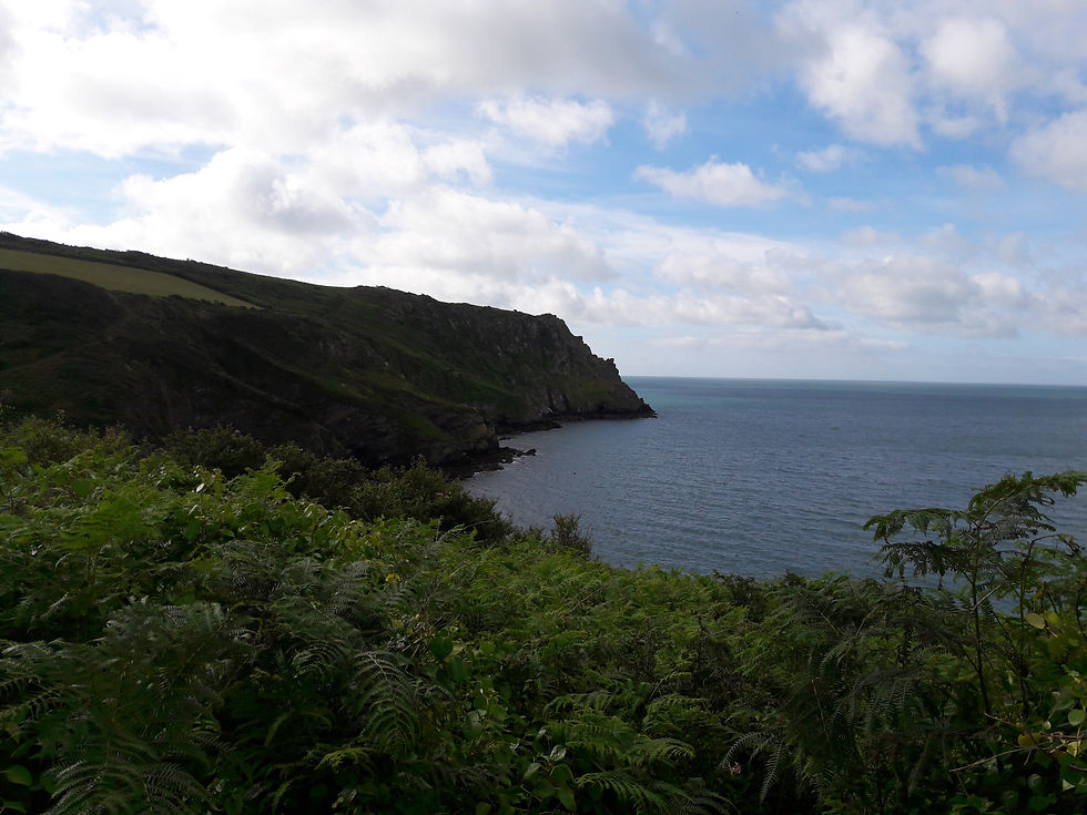
Parking at the National Trust car park on Nare head, I ventured down a steep field opposite, which I assumed led to Kiberick Cove. It turned out that it led to some cliffs overlooking a cove, but without signage to indicate where I actually was!

This was the view of the cove from the top of the field, but my Bartholomew's guide to walking the Cornish Coast Path doesn't have a map of the whole of Nare Head (it's split over two legs of the walk and therefore on two pages!), so I wasn't entirely sure where I was looking at!
I headed off up the steep climb to Nare head (left to right in the picture above).
A gusty day meant that once I got to the top of the head, it felt quite cold, but I immediately found something that grabbed my attention.
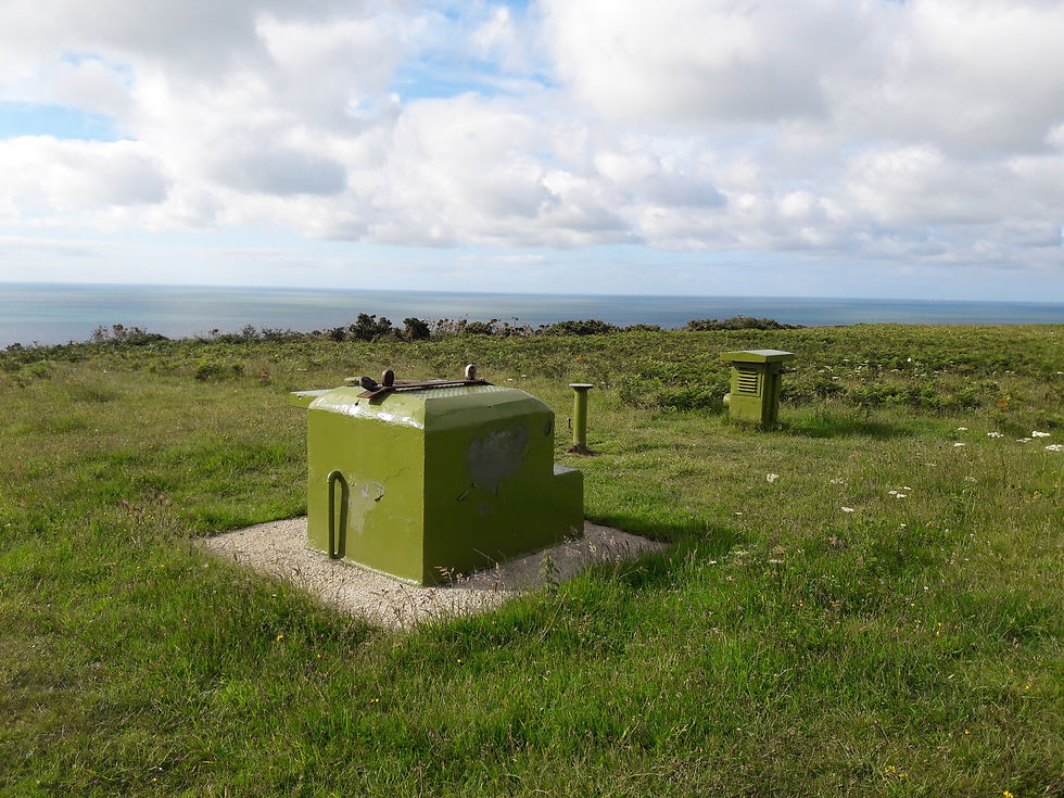

Luckily, there was an excellent information board which explained what these two pictures show and, to save me typing all the detail I took a picture of it. But as you won't be able to enlarge the photo (unless you're cleverer than me) I'd better give you some clue!

So, the bunker entrance was part of a sophisticated decoy site constructed during WWII which was used to lure enemy planes away from areas of strategic importance (in this case Falmouth Docks).
The ventilation shafts are part of a nuclear bunker built in 1962 and was designed to serve as a survival unit for three officers of the Royal Observer Corps, where they could live for three weeks after a nuclear strike monitoring radiation levels. It was closed in 1991.
Unfortunately, toady was not one of the very few days that you can visit the bunker, but rest assured, I will keep looking for the opportunity to get inside these structures and have a nose around!
The path descends steeply down the Western side of Nare head, you pass the ruins of Mallet's cottage before reaching the bottom of the incline and starting back up the other side!
Some details can be found here : https://www.nationaltrust.org.uk/roseland/trails/nare-and-back-again
The walk becomes a bit easier now, with less harsh ups and downs once you have reached Carne. If the tide is low, you can walk across Pendower beach as far as Pendower it's self (Currently, the actual path is closed due to Coronavirus because it goes through the grounds of the Nare hotel, which meant a detour inland for me on the way out).
The path goes along the road (Rocky lane) a little way as you leave Pendower then turns left after a large white house (Pendower Court).
Easy walking follows (except for the rather overgrown state of some parts of the path, where Brambles, Nettles and protruding branches / sticks can be a problem) until the path drops down onto Porthbean Beach for a few steps, before some steps up off the beach and on up through the woodland.

A fairly level stroll for the next mile and a half takes you past the Portscatho coast guard lookout point, past Porthcurnick Beach and into Portscatho.

The drama of the day happened far out in Gerran's bay, where a Lynx helicopter could be seen close off the aft of a vessel. For the next hour, the helicopter remained in the same position, whilst the vessel made it's way towards Falmouth. The helicopter was very low as the downdraft of the rotors was whipping the sea up around it. I asked the female Coast watch volunteer at Portscatho if she knew what was going on, but if she did, she wasn't telling!
So, the return walk was uneventful, until I got to where I had started, when I still couldn't decide if the cove below the cliff I was on was Kiberick Cove. Now being the type of person I am, I didn't want to misrepresent my walk today or indeed the whole sponsored effort. Therefore, I walked and extra three quarters of a mile until I reached the other side of the cove and struggled up the steep slope and down the other side until I could see the path ahead. I'd like to pretend that it was the visible topography that convinced me that I was now past Kiberick Cove and above a certain Parc Gargloose Cove. However, that would be a lie. It was of course Google maps that finally proved I had walked beyond Kiberick Cove and that I was in the right place all along when I started today (shame I couldn't get a signal on Nare head!!
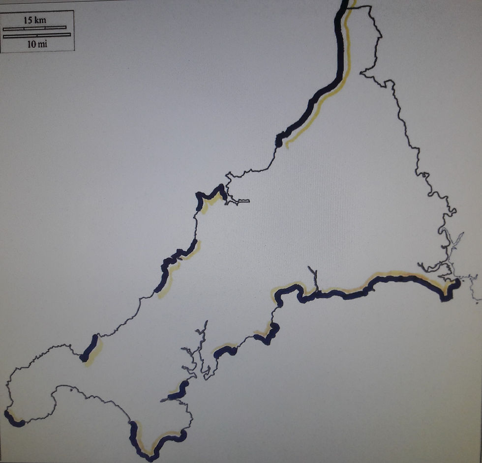
314.3 miles now completed in 27 days. Only another 264 miles to go. Here's how my progress looks on a map of Cornwall (thick shaded areas walked in both directions)
Fundraising stuck at £447.40, but only thanks to ten generous donors (one who has doubled every contribution made so far), so if you have enjoyed reading my Blogs (or, found the words tedious but just enjoyed looking at the pictures) and you can help, please do.
Now I must close, to watch the stream of a real London Derby - Charlton Athletic against Millwall, Come on you Reds!


Comments