Day 50 - The end...back where my love of the Cornish coast path began.
- Paul Juckett
- Jul 31, 2020
- 5 min read
Back in 1981 (I think it was April / May time) my family took a holiday to Mousehole, I think it was for a couple of weeks (my memory on the detail is scratchy) but I have some fantastic memories of that holiday.
We caught the train from London (Family Railcard obviously) and alighted a Penzance station. In those days the Blue bus used to run to Mousehole and when it arrived my Mum asked the driver for "one way tickets to Mousehole" (Pronouncing Mousehole as it's spelt). I remember the bus driver laughing and saying the bus didn't go to Mousehole, but he'd drop us at Mowzel which was just as nice. So my love of Cornwall began through a pronunciation lesson (M ow zel). The holiday included a walk between Mousehole and Lamorna Cove and back and I ave loved the Coast path ever since.

Today I once again alighted the train at Penzance, although twenty years of working on the railway in Devon and Cornwall has somewhat diminished the thrill of the journey through Cornwall and into the imposing engine shed of Penzance station (familiarity breeding contempt?).
This time, unlike forty years ago, I did not take the Blue bus (which is now called "The Mousehole" and runs every twenty minutes) instead I walked, enjoying the ever increasing strength of the sun on my back.
The walk from Penzance station takes you along the main road for around a quarter of a mile passing the sailing club and a small harbour, before you come to the main harbour where the Scillonian ferry sails from. Past the Dolphin Tavern and the Waterside Meadery round to the Jubilee Pool (an open air sea pool) and the start of the Promenade (Currently being reinforced with concrete after several storms damaged it badly.
A walk of approximately three quarters of a mile, brings you to the start of Wherrytown beach, where the coast path runs between the sea and a park and bowling club. A short walk from here brings you into Newlyn, the centre of the Cornish fishing industry.

With it's large harbour (a little of which is captured in the photo above - note how gloomy the weather is! This was taken on the way back at around 12:30 hrs - more on the weather soon!) and busy fish market (more than 600 boats supply the market daily) the fishing industry sustains the town (I counted six separate fishmongers in around half a mile) being a major employer directly and indirectly (boat yards, marine engine sales, deliveries etc.).
I continued through the narrow streets until, after a short way, the coast path branches away from the main road and along the shoreline. This relative tranquility last's for about a thrid of a mile, before the path leads back up to the road and stays there more or less all the way to Mousehole.
A point of incredible poignance and interest is the Penlee lifeboat station (about a mile from Newlyn and less than half a mile from Mousehole). The station was closed in 1983 and moved to Newlyn harbour under the same name, after a larger lifeboat was provided. The Penlee lifeboat disaster of December 1981 shocked the nation to its core, when the entire eight man crew of the lifeboat Solomon Browne was lost whilst attempting to save the crew of the Union Star in a hurricane force storm (100 MPH winds and waves up to 60 feet).
You can learn more here: https://en.wikipedia.org/wiki/Penlee_lifeboat_disaster
I remember being shocked that people that I had (in all probability) seen or spoken to just six or seven months earlier had been killed whilst VOLUNTEERING to risk their lives to save others - A genuine example of 'Service not Self' the motto of the Royal British Legion.
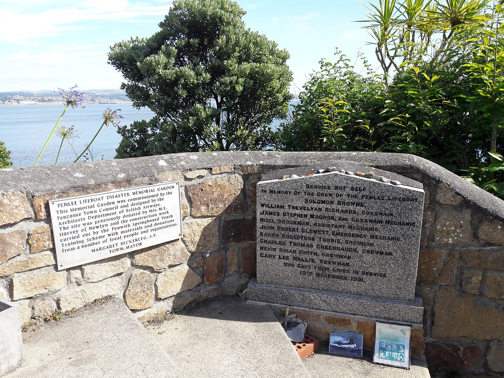
The picture above (taken at around 10:00 hrs when the sun was out and bright) is of the plaques on the entrance of the memorial garden that sits alongside the Penlee lifeboat station.
I continued on to Mousehole and spotted the house that we rented all those years back. Then it was split into two flats (upstairs and downstairs) and we rented the upstairs flat. The middle room at the front was the kitchen and every morning the seagulls sat on the roof below the window and sqwauked for food (obviously previous holiday makers had got them in the habit of being fed), my Mum did nothing to discourage them, throwing them bits of bread - I think secretly she enjoyed the act that us children were driven out of our beds at stupid o'clock each morning!
Now, the roof has gone and it is being heavily renovated.

A short walk from here got me to the harbour, which looked as picturesque as it always does.

The picture above was taken at around 10:30 hrs, note the thickening clouds!
I headed through the narrow streets and out of the village up the steep hill towards Lamorna cove, until the road bends sharply right. At this point the footpath leads off to the left and begins its way across the cliffs.
Fairly well enclosed by the hedge and trees for the first half mile, I was surprised to emerge into the more exposed part of the cliffs to find that a sea mist had begun to creep inland.

The woods in view are Kemyel Crease nature reserve, but to my family they were known as Pixsies wood (For the record - no pixsies were ever seen).
From this point on, the path gets a little up and down, although none of the climbs or descents are very long, until you pass through the woods when you get a bit of flat low level cliff with stunning views of St. Michael's Mount (see picture below)

The path then climbs up to Carn Du (the highest point on this walk - pictured below), before a gentle (but sometimes tricky) descent to Lamorna Cove (below below).


As it was now beginning to rain, I hurried back towards Mousehole (after resisting the urge to grab a Cream Tea form the Lamorna Cove Cafe (legendary in my mind, the first cream tea I ever had).
Passing through Mousehole, I couldn't resist taking a photo of the islet offshore (St. Clement's Isle). It sits 380 yards offshore and back in 1981 my brother and I attempted to reach it in our rubber dinghy (not suitable for use at sea). After a mere 100 yards, with ripples running under the dinghy and worrying me, my big brother thought it would be hilarious to convince me it was sharks swimming under the dinghy. I set a new world record for the 100 yard dash in a dinghy as I rowed ashore!

I reached Penzance station and concluded my challenge. I have walked the entire Cornish Coast Path twice, albeit section by section rather than in one long hike North round to South and vice versa. I have walked a total of 586.1 miles and ascended and descended nearly 14 miles.
Look out for the final entry of this BLOG sometime next week, when I sum up my aches and pains, pick my highlights and lowlights and, most importantly announce the total I have raised.


Comments